


Marine Ways - Nautical Charts
Descriere Marine Ways - Nautical Charts
Marine Ways Boating este cea mai bună aplicație de planificare și navigație marină! În această aplicație veți avea acces la:
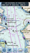
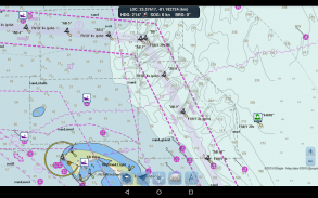
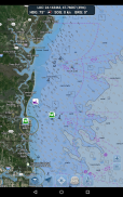
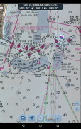
HARTE DE NAVIGAȚIE
- Hărți ale Statelor Unite oferite de Administrația Națională pentru Oceanii și Atmosfera (NOAA)
- Hărți din Noua Zeelandă oferite de Land Information New Zealand (LINZ)
Tipuri de diagrame:
- NOAA Electronic Navigational Charts (ENC) (cel mai nou și mai puternic produs de cartografiere electronică de la NOAA).
- Diagrame clasice NOAA (inclusiv versiunile Zi, Roșu, Amurg, Noapte și Gri).
- Diagrame LINZ (disponibile în prezent numai în versiunile de zi, amurg și noapte)
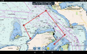
INSTRUMENTE DE PLANIFICARE RUTE
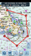
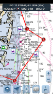
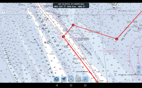
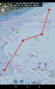
-Tracerea traseului. Atingeți și mențineți apăsat pe hartă timp de o secundă pentru a vă reprezenta punctele de referință. Pentru a forma un traseu, continuați să atingeți lung pe hartă în diferite zone. Distanța și direcția sunt calculate și afișate în mod convenabil pentru fiecare picior pe măsură ce adăugați, ajustați sau eliminați puncte de referință.
-Mod de călătorie. Centrează automat harta pe poziția curentă pe măsură ce vă deplasați. Utilizați modul de călătorie pentru a vedea cât de aproape urmăriți traseul trasat în timp real!
-Rezumatul etapei traseului. O vizualizare convenabilă care conține informații detaliate despre fiecare picior pe care l-ați trasat, inclusiv coordonatele de început și de sfârșit, distanța și direcția.
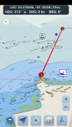
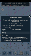
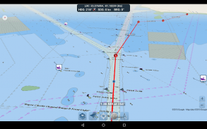
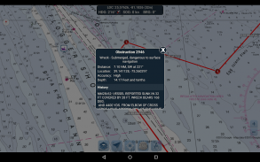
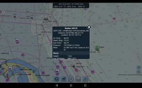
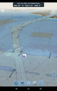
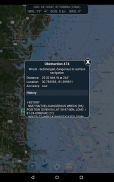
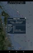
RAPOARTE DE GEAMANDARE ȘI INFORMAȚII DE OBSTRUCȚIE
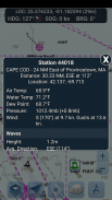
Marcatoarele pentru geamanduri și obstacole sunt trasate convenabil în locația lor reală pe hartă! Doar faceți clic pe marcator pentru a vedea informațiile lor!
- Rapoarte despre geamanduri: obțineți rapoarte complete despre condițiile actuale și despre valuri pentru geamanduri fixe și în derivă.
- Obstacole: obțineți informații despre locație și istoric despre pericole potențial periculoase, scufundate, inclusiv pietre și nave scufundate.
TABLA DE BORD DE NAVIGAȚIE
Tabloul de bord de navigare afișează diverse informații în timp real, inclusiv:
- Locația curentă (latitudine și longitudine, cu interval de precizie)
- Direcția curentă (include și o mică busolă direcțională!)
- Viteza curentă peste sol
- Rulment de curent
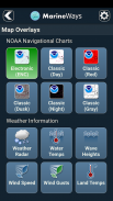
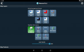
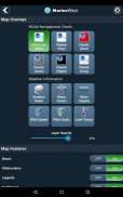
SUPRAVUNERE HARTĂ MARITĂ
Comutați diferite date de suprapunere marine direct pe hartă pentru a vă face o idee mai bună despre condițiile actuale de navigare!
Suprapunerile includ:
- Temperatura suprafeței apei (globală)
- Vitezele vântului (numai SUA)
- Rafale de vânt (numai SUA)
- Înălțimile valurilor (numai în SUA)
ÎMPĂRȚIREA LOCATIEI PE APĂ / VEZI ALTE BĂRCI
- Afișați ultima locație cunoscută, viteza, direcția și numele bărcii pe hartă pentru ca alți navigatori Marine Ways să le vadă.
- Vedeți ultima locație cunoscută, viteza, direcția și numele bărcii altor navigatori Marine Ways, precum și distanța și direcția acestora față de locația dvs.
- Partajarea locației este dezactivată în mod prestabilit. Când sunteți gata să partajați, activați-l în setările generale. Pentru a vă actualiza continuu locația pe hartă, mențineți aplicația deschisă și concentrată. În prezent, aplicația nu vă actualizează locația în fundal.
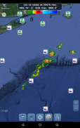
INFORMAȚII METEO
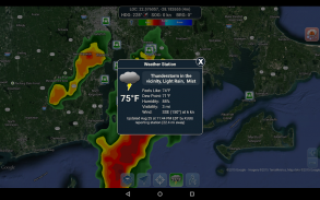
- Radar de precipitații meteorologice (numai în SUA și Hawaii). Detectează orice ploaie și ninsoare în zonă.
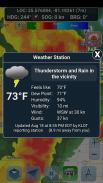
- Stație meteorologică. Raportează cele mai apropiate date ale stației de observare. Temperatura actuală, umiditatea, condițiile meteo, vânt și multe altele! Datele de observare a stațiilor sunt disponibile la nivel global.
- Alerte meteo. Stația meteo raportează, de asemenea, orice alerte meteo active emise de Serviciul Meteorologic Național, cum ar fi avertismente de furtună puternică sau avertismente de uragan. Informațiile de alertă meteo sunt disponibile pentru SUA, Alaska și Hawaii.
- Suprapunerea temperaturii suprafeței terenului. Afișează temperatura actuală a suprafeței pe uscat (numai în SUA).
Înainte de a utiliza această aplicație, vă rugăm să citiți și să fiți de acord cu următorii termeni de utilizare/serviciu și politica de confidențialitate:
Condiții de utilizare / serviciu: http://www.marineways.com/appterms
Politica de confidențialitate: http://www.marineways.com/appprivacy
Disclaimer privind hărțile de navigație de la NOAA:
NOAA ENC Online nu este certificat pentru navigare. Capturile de ecran ale ENC-urilor afișate aici NU îndeplinesc cerințele de transport cu hărți pentru navele comerciale reglementate conform Titlurilor 33 și 46 din Codul Reglementărilor Federale.
Bucurați-vă de aplicație! Marine Ways este, de asemenea, disponibil pe web la http://www.marineways.com
Marine Ways - Nautical Charts - Versiune 1.41
(01-01-2025)Marine Ways - Nautical Charts - Informații APK
Versiune APK: 1.41Pachet: com.marineways.androidCea mai recentă versiune a Marine Ways - Nautical Charts
Alte versiuni


Aplicații din aceeași categorie

S-ar putea să îți placă și...


